Log in
All resources
Create a design
90 Free Artworks of Old Maps Of Germany
baroque
matthäus merian
copper engraving print
bibliothèque nationale de france
joan blaeu
engravings of topographia saxoniae inferioris
atlas maior, vol 3 (germany) - joan blaeu, 1667 - bl 114.h(star).3
maps by john cary
john cary
old maps of westphalia
the discovery of guiana
theodor de bry
russo-turkish war (1877–1878) in art
great eastern crisis (1875–78)
maps by cornelis anthonisz.
1560 maps of europe
oranienburger straße (berlin-mitte)
paintings by eduard hildebrandt
tourism advertising posters of germany
1935 maps of germany
mannheim in the 17th century
baroque
parts of old maps of hamburg
steintor (hamburg)
daniel friedrich sotzmann
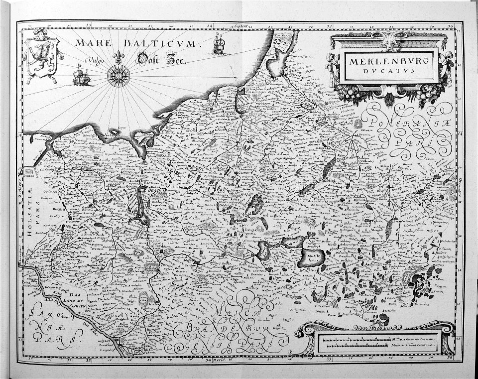
old maps of pomerania
nürnberger reichswald
1559 maps of germany
maps in cosmographia (münster)
old maps of kempten (allgäu)
old maps of cities in germany
baroque
topographia franconiae (merian)
baroque
maps by john cary
1799 maps
1801 maps of germany
maps by john cary
maps by john cary
1801 maps
maps of vogtland
joan blaeu
maps, prints and photographs in royal danish library
old maps of kiel
engravings by matthäus merian
baroque
maps of moers by johannes mercator
old maps of duisburg
russo-turkish war (1877–1878) in art
great eastern crisis (1875–78)
old maps of manhattan, new york city
1851 maps
maps by matthäus seutter
kačina
maps by john cary
1799 maps
collections of the kriminalmuseum rothenburg ob der tauber
old maps of rothenburg ob der tauber
engravings of topographia saxoniae inferioris
baroque
hamburg in topographia saxoniae inferioris (merian)
baroque
old maps of westphalia
sharp s
old maps of ravenstein, germany
maps made in the 17th century
engravings of topographia saxoniae inferioris
baroque
engravings of topographia superioris saxoniae, thüringiae, misniae et lusatiae (merian)
baroque
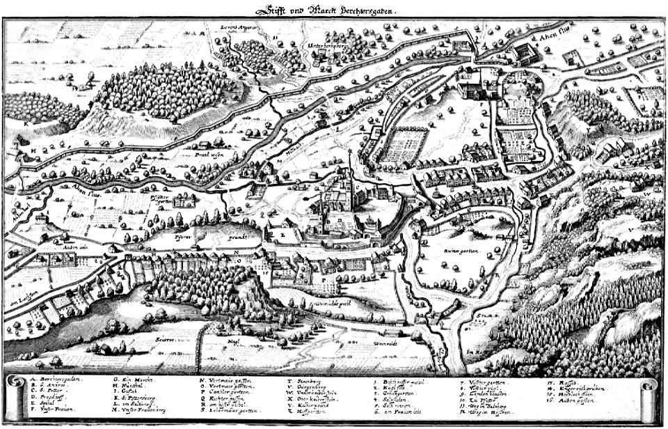
augustinerchorherrenstift berchtesgaden
baroque
topographia westphaliae (merian)
baroque
1640s maps of hesse
old maps of nassau
engravings of topographia saxoniae inferioris
baroque
parts of old maps of bremen
baroque
old maps of freiburg im breisgau
gregorius sickinger
engravings of topographia superioris saxoniae, thüringiae, misniae et lusatiae (merian)
baroque
engravings of topographia saxoniae inferioris
baroque
maps by willem and johannes blaeu
old maps of westphalia
engravings of topographia superioris saxoniae, thüringiae, misniae et lusatiae (merian)
baroque
maps of fossa eugeniana by willem and johannes blaeu
old maps of north rhine-westphalia
old maps of piedmont
maps by gerard valck
map of the german empire by louis stanislas d'arcy de la rochette
1780s maps of lithuania
maps by alexis-hubert jaillot
maps by guillaume sanson
atlas maior, vol 3 (germany) - joan blaeu, 1667 - bl 114.h(star).3
maps by wolfgang lazius
atlas maior, vol 3 (germany) - joan blaeu, 1667 - bl 114.h(star).3
old maps of moravia
jewish cemetery battonnstraße
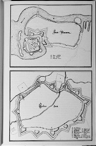
fabers belagerungsplan
atlas maior, vol 3 (germany) - joan blaeu, 1667 - bl 114.h(star).3
johannes gigas
atlas maior, vol 3 (germany) - joan blaeu, 1667 - bl 114.h(star).3
johannes gigas
maps by john cary
1799 maps
engravings of topographia saxoniae inferioris
baroque
daniel de la feuille
old maps of bavaria
maps by alexis-hubert jaillot
maps by guillaume sanson
1704 works in germany
old maps of ulm
old maps of westphalia
bindenschild
geometrischer grundriss von frankfurt am mayn (1811)
maps of frankfurt-innenstadt
old maps of swabia
maps by john cary
old maps of westphalia
johannes gigas
engravings of topographia superioris saxoniae, thüringiae, misniae et lusatiae (merian)
baroque
engravings of topographia saxoniae inferioris
baroque
maps by jodocus hondius
old maps of nassau
celeberrimi fluvii albis nova delineatio by willem janszoon blaeu
old maps of germany from deutsche fotothek
géographie générale; physique, politique et économique (1876)
1870s maps of germany
atlas maior, vol 3 (germany) - joan blaeu, 1667 - bl 114.h(star).3
johannes gigas
engravings of topographia saxoniae inferioris
baroque
landkreis eichsfeld in the 17th century
maps from gallica
old maps of regensburg
baroque
1750s maps of saxony
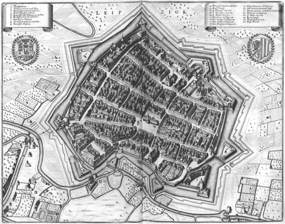
old maps of leipzig
a treatise on ore deposits (1896)
1890s maps of saxony
unidentified locations in germany
a treatise on ore deposits (1896)
atlas maior, vol 3 (germany) - joan blaeu, 1667 - bl 114.h(star).3
collections of the nederlands scheepvaartmuseum
maps from the earth and its inhabitants, vol. iii
old maps of bonn
lehen (freiburg im breisgau)
baroque
maps by alexis-hubert jaillot
old maps of duchy of cleves
atlas maior, vol 3 (germany) - joan blaeu, 1667 - bl 114.h(star).3
old maps of upper austria
maps by alexis-hubert jaillot
old maps of duchy of cleves
maps by jakob van der schley
old maps of stralsund
history of schwäbisch hall
baroque
david rumsey historical map collection
old maps of the holy roman empire
old maps of rhineland-palatinate
daniel de la feuille
old maps of emmerich am rhein
baroque
old maps of the polish-lithuanian commonwealth
1790s maps of poland
old maps of the history of france
daniel de la feuille
cartography and geographical illustrations of the wehrmacht
trondheim in the 1940s
old maps of duchy of cleves
guillaume sanson
engravings of topographia saxoniae inferioris
baroque
prints by jan luyken in the rijksmuseum amsterdam
maps in the rijksmuseum amsterdam
old maps of mainz
baroque
dutch 17th-century prints in the rijksmuseum amsterdam
capture of brielle
maps in the rijksmuseum amsterdam
old maps of germany
1 - 90 of 90
/ 1